OpenStreetMap community

4167 readers
1 users here now

Everything #OpenStreetMap related is welcome: software releases, showing of your work, questions about how to tag something, as long as it has to do with OpenStreetMap or OpenStreetMap-related software.

OpenStreetMap is a map of the world, created by people like you and free to use under an open license.

Join OpenStreetMap and start mapping: https://www.openstreetmap.org.

There are many communication channels about OSM, many organized around a certain country or region. Discover them on https://openstreetmap.community

https://mapcomplete.org is an easy-to-use website to view, edit and add points (such as shops, restaurants and others)

https://learnosm.org/en/ has a lot of information for beginners too.

founded 5 years ago
MODERATORS
151


The German chapter of OpenStreetMap, FOSSGIS e.V., has voted unanimously to a commitment providing annual financial support to the OpenStreetMap foundation. This is a first-of-its-kind decision for an OpenStreetMap local chapter, reflective of the German OSM community’s relatively large size and financial resources, as well as its strong commitment to the OSM project.

152


In the web UI, OSM can't be zoomed in far enough to see the names of POIs in reasonably dense areas. I can get around this by going into edit mode, and mobile apps don't have this restriction. But the out-of-the-box experience, for non-insiders just using the web site, doesn't reveal all that OSM has to offer.

Does anyone know what the rationale for this is?

153
118
Me, whenever I try to map level=0 (youservewell.isnichwahr.de)
submitted 2 years ago* (last edited 2 years ago) by redd@discuss.tchncs.de to c/openstreetmap@lemmy.ml
154


This and more changes in Carto Style v5.8.0

If you know nice places with flowerbed, please feel free to share!

155
156
2
submitted 2 years ago* (last edited 2 years ago) by redd@discuss.tchncs.de to c/openstreetmap@lemmy.ml


things experienced by me:

  • site not loading / slow loading
  • map data not loading (from sidebar)

Update: Editor ID map data loading takes long time

Update 18:30 CET: Everything appears to be normal again

157


The longest current OpenStreetMap username is "bwdlqwbdjlbqlwdjbqlwjdbqljwbdlqwjbdlqwjdblqjwbdlqjwdbqlwjdblqwdblqjbdlqjwbdljqbwdljqwbdlqbwdbqwdblqwdlqwbdlbdlqbwldbqlwbdlqbwdlqbdlqbdljwbdlqwbdwlbqlwdblqwbdjlqwbdjlqwbdljqwbdljqbwdljqbdlqwbdlqbdljqbdljqbwdljbqldbqlwdbljqwbdljqwdbqlwdbqlwjdbqlwdbqlw".

158


I'm trying to tag a new bus route (which includes new stops) but I'm not sure which option is best. Looking at some of the current stops, there are multiple of them which have been tagged slightly different (see examples below).

Stop v1, Stop v2 & Stop v3

I guess my question is whether or not I should be creating the node on the road always and if another should be created when there is a larger stop/platform (like the examples)

side note: I created a new bus route as a relation but when trying to add it to other stops on the route it doesn't appear (I've uploaded the changes).

159
160


Some work for the OpenStreetMap community in 2024… 😀🚰

“Free drinking water soon available in Belgium's 100 largest train stations”: https://www.brusselstimes.com/belgium/810782/free-drinking-water-soon-available-in-belgiums-100-largest-train-stations-tbtb

So, how would you tag this ?

amenity=drinking_water
fountain=bottle_refill
access=yes
wheelchair=yes
fee=no
operator=NMBS/SNCB

#OpenStreetMap #Belgium #water #SNCB #NMBS

cc: @openstreetmap

161


#OrganicMaps integrated #Kayak referral button on its app, WHY!? 😩 @openstreetmap @organicmaps

Edit: good debate on the PR, read before commenting, do not make the same mistake as me 😥: https://github.com/organicmaps/organicmaps/pull/6523

https://github.com/organicmaps/organicmaps/releases/tag/2023.11.17-17-android

162
163
164


i'm on mostly on android so excuse my unfamiliarity.

i was talking about osm with an apple fan. There's osm and organic maps on app store but is there an app like street complete for iPhoners?

165


Summary of the video (generated by Kagi):

  • Addis Map Transit works to map public transportation in Addis Ababa, Ethiopia using OpenStreetMap. They have mapped bus routes, stations and worked to provide digital transportation information services.
  • Digital Matatus Consortium worked to map matatu (mini-bus) routes in Nairobi, Kenya to provide open transportation data and analyze accessibility issues. They standardized the data in GTFS format.
  • Truy Association helps make public transportation easier and more accessible in the global South through mobile apps and open data. They encourage communities to map their transportation systems.
  • Mobility Hub created an online course to teach people how to map public transportation in OpenStreetMap, covering topics like GTFS and using the JOSM editor.
  • Mapping transportation helps provide digital route planning apps and services, empowering users and operators. It also allows analysis of issues like access to services.
  • Open data standards like GTFS are important to make transportation data usable in apps and analysis. Converting OSM data to GTFS was a focus.
  • Community involvement and crowdsourced data helps keep transportation maps accurate and up-to-date as systems change.
  • Presenters discussed challenges like gaining permissions and maintaining government relationships and data.
  • Transportation mapping empowers underserved groups and improves planning and equitable access to opportunities.
  • Open source tools, networks and training are needed to support mapping efforts globally, especially in the global South.
166


How would you map a refill shop on OSM? Those places you can go with containers and buy by weight.

@openstreetmap@lemmy.ml @openstreetmap@a.gup.pe #OpenStreetMap

167


I did not yet fully understand this proposal in its current state, since there are lot of different possibilities to tag sidewalks, footpathes etc.

What do you think?

168


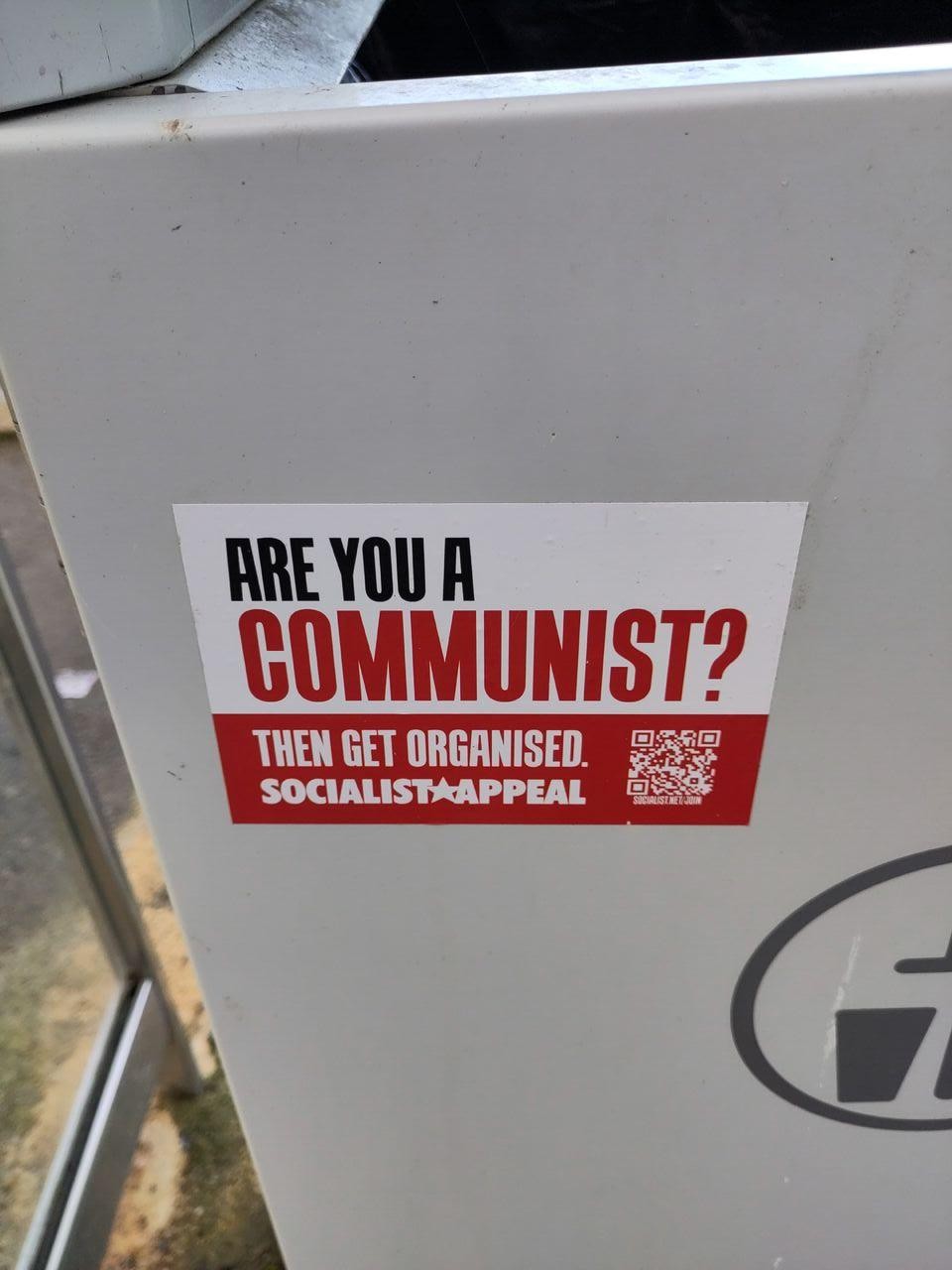
I've been out mapping local bus routes recently. Some photos from the camera roll that aren't of bus stops @openstreetmap@lemmy.ml @openstreetmap@a.gup.pe

#Oxford #OpenStreetMap #communism #horses #ParkAndRide #PhoneBooth

169


How many of them did you create?

170


Is there a way to overlay property lot lines (aka land ownership maps) on the map of preferably a mobile FOSS application? I like OSM And and I know there are ways to make certain obscure things work. OnX Hunt has this feature but I don't want to use the application

171


hello!

Is there an app that can make routes for wheelchair users? #OpenStreetMap contains the info about staircases, ramps, curbs, all aspects of accessible or inaccessible city environment, someone should be using it

Or is there a convenivent interface for viewing this kind of data? So we don't have to view it through #osm editors

172


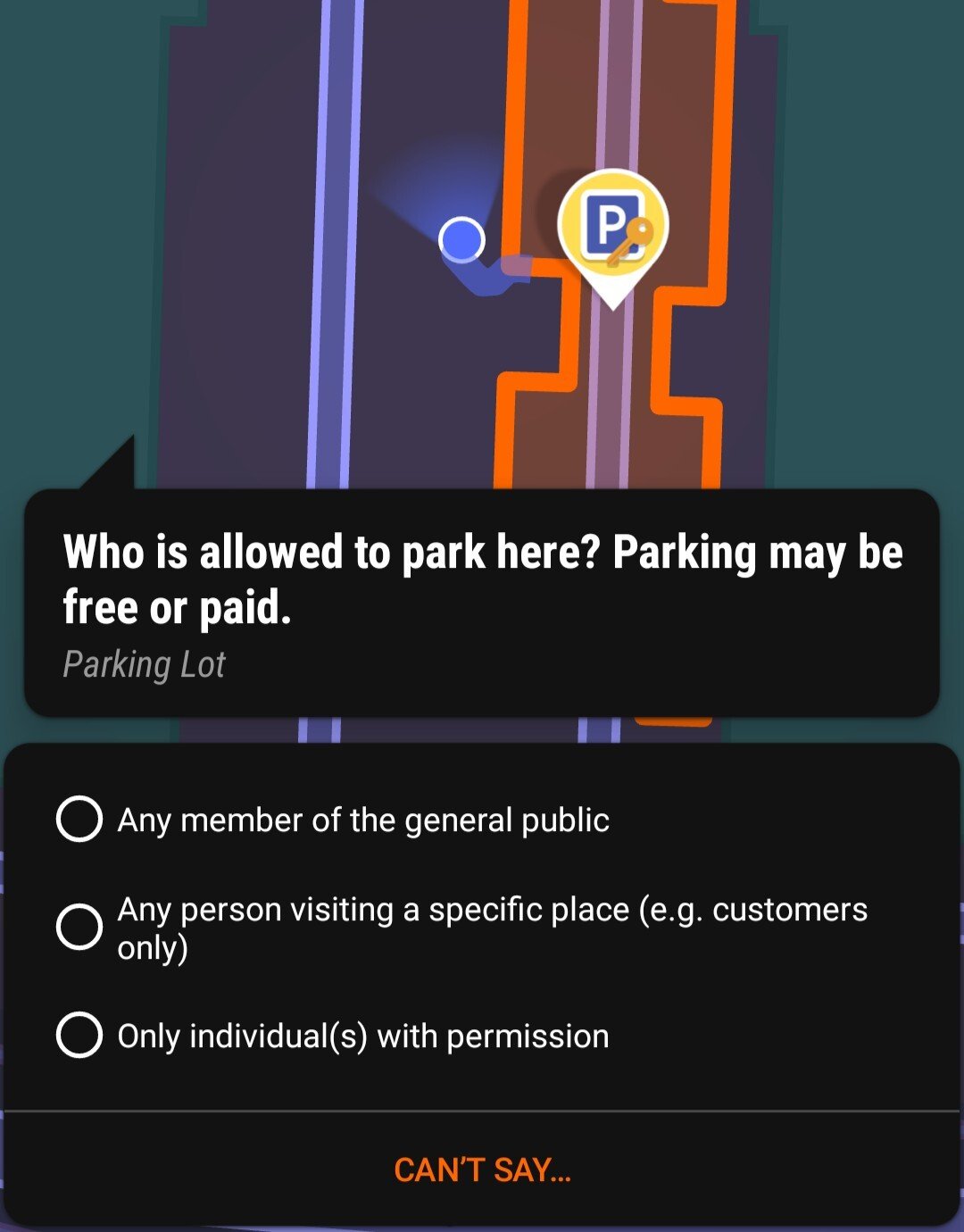
I was out walking around and "popping" quests on StreetComplete. I was wondering what the consensus is on the question "Who is allowed to park here?" In this case, it's an ungated parking lot next to a commercial/industrial warehouse with many companies occupying the same space. A few of the parking spots had a sign indicating "reserved for XYZ customers", but most did not. This is not a city-owned parking lot. What's the right answer?

173


How many of them did you create?

174
175


It seems pretty clear that street-level imaging on OSM is pretty lacking, unless you only want to see highways.

I'm looking to start mapping street-level images for my city, but it seems like there are three players (integrated in the OSM editor), and I don't know which to commit to:

-KartaView

-Mapillary

-mapilio

My gut is to go with the one with the largest user base (Mapillary), but they are owned by Facebook and who knows what direction they will take in the future or what our images will actually be used for in the long-run.

Karta seems dead.

And Mapilio seems like a knock-off of Mapillary, but with a much smaller user base and an uncertain future.

Are any worth investing hundreds of hours of time to?

view more: ‹ prev next ›